
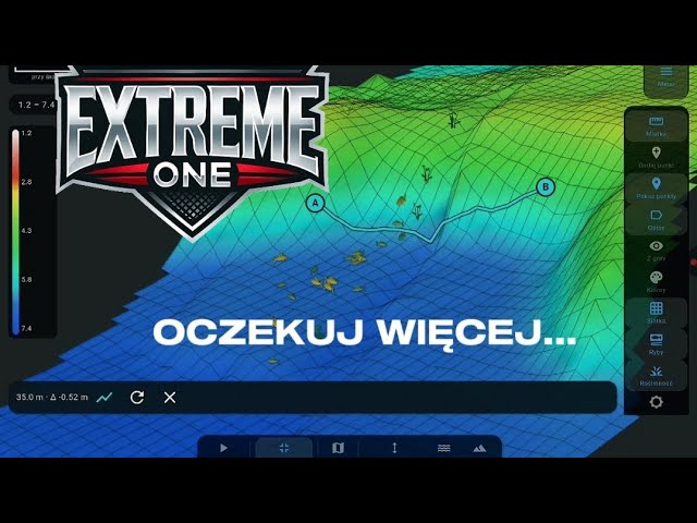
3D Ruler in Extreme One – Measuring Distance Along the Lake Bottom
3D ruler is a tool in the Extreme One app that measures the real distance along the shape of the lake bottom, not in a straight line above the surface. The difference can be significant, and the more varied the swim, the bigger it gets.
How the 3D ruler works
A regular distance measurement between two points treats the bottom like a flat board. This tool draws the line along the actual bottom profile, taking slopes, humps and uneven ground into account. On a slope, in a gully or at the edge of a plateau, the real path along the bottom is longer than the segment drawn on a bird’s-eye map.
In addition, the 3D ruler shows the depth difference between selected points. Instead of guessing how many metres deeper one end of a drop-off lies than the other, you read it straight from the screen.
What it is useful for on the water
It is most useful for reading bottom structure. If you are looking for a drop-off, a step or a local shallow spot, the depth at a single point says little. Only comparing two points and the depth difference between them shows whether it is a gentle slope or a steep wall.
- planning a baiting route along a drop-off rather than across it
- judging how steep the slope is at a chosen spot
- comparing two swims in terms of depth difference
- a more accurate analysis of bathymetry after a scan
Where the measurement data comes from
The 3D ruler uses a bathymetric map built earlier by the fish finder. The denser you cover the swim while scanning, the more accurate the profile you get, and as a result the more reliable the measurement. On a sparse scan, the app interpolates the bottom between passes and the ruler will show an averaged profile.
On the hardware side you need a fish finder that shows the full water column, for example the EXTREME-MASTER SONAR S300, and the EXTREME-PILOT autopilot, so that scanning passes are straight and repeatable. Manual steering gives uneven lines, which are harder to combine into a consistent map.
What this tool cannot do
It does not replace a scan. If you have never covered a given part of the swim, the app has nothing to calculate the profile from and the measurement there will only be an approximation. It also does not account for weed or silt: it measures the bottom line determined by the echo, not the top of the vegetation.
How to make a scan that gives reliable measurements
The accuracy of the 3D ruler starts at the scanning stage, not at the measurement itself. A few things make the biggest difference here.
- Even, parallel passes – the denser they are, the less the app has to interpolate between lines. On a small water it is worth going down to a few metres of spacing.
- Constant, low speed – a boat racing across the water collects sparser samples and misses small bottom irregularities.
- Calm water – waves rock the transducer and add noise to the depth readings.
- Autopilot instead of hand steering – repeatable straight lines are hard to hold by hand, and they are what makes the map consistent.
With such a scan, the tool shows the real profile. With a scan made in a single pass through the middle of the lake, it will mostly show what the app has guessed.
Frequently asked questions about the 3D ruler
Does the tool work without a previous scan?
Not fully. Without fish finder data, the app does not know the bottom profile and can at most show the straight-line distance. The feature only becomes meaningful on a scanned part of the swim.
How is it different from a regular distance measurement?
A regular measurement is a segment between two points on a flat map. Here that line runs along the bottom and its real length is added up, and with large depth differences the result can differ noticeably.
Does the depth difference take the water level into account?
It shows the depth difference between points at the time of scanning. If the water level in the lake has changed since then, absolute depths will be shifted, but the difference between the points stays the same.
Measuring along the bottom and planning your baiting
You get the most out of the 3D ruler when setting up your swim. The distance measured along the bottom matches what your rig actually travels over and what the bait rolls along, especially on a slope. Boilies dropped over a drop-off do not stay where they landed – they roll down the slope, and the steeper it is, the further they go.
Knowing the depth difference between points makes it easier to predict where the bait will actually stop and to move the drop spot higher or lower. The same goes for choosing the distance to mark with a marker: a straight-line measurement can underestimate the real distance on a varied bottom.
The 3D ruler works in the same app as the other Extreme One features, together with the 3D Lake view and bathymetric maps. If you have updated the app recently, also check out the new screen themes introduced in version 2.1.112. We show more videos regularly on our YouTube channel.
 Asystent pomocy Extreme One