
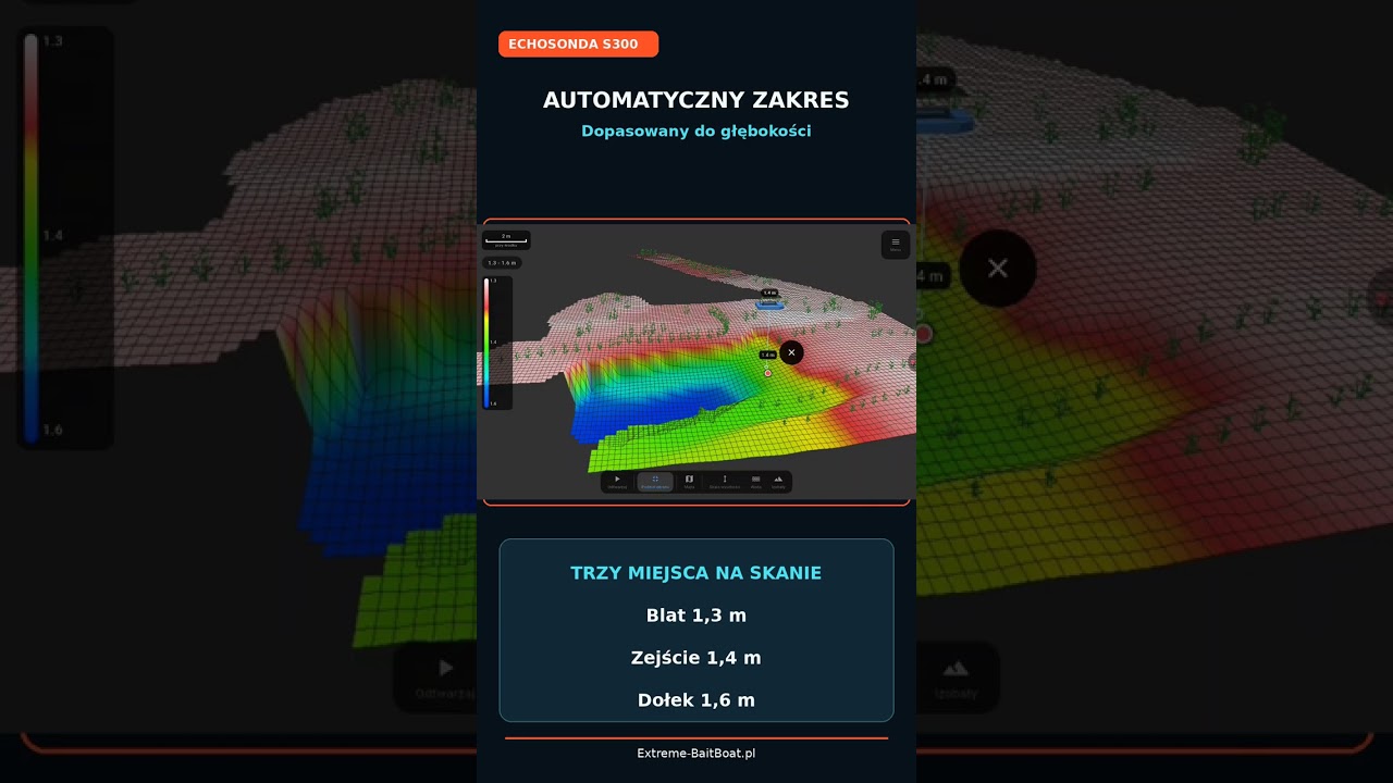
Uroczysko Karpiowe in 3D – plateau, drop-off or hole? A scan from a match
You arrive for a match at Uroczysko Karpiowe. The bait boat heads out onto the water while you calmly set up your swim. Before your rods are even on the pod, you can already know what lies beneath the surface. This time we are showing a real scan made by an Extreme One user straight from the match.
Uroczysko Karpiowe in 3D: plateau, drop-off and hole
At first glance it looks like a flat, shallow plateau. But one look at the 3D model is enough to see a gentle drop-off into deeper water:
- 1.3 m on the plateau,
- 1.4 m on the drop-off,
- 1.6 m in the hole.
The difference is only 30 centimetres, and yet there are already three spots worth thinking about before you place your rig. In shallow water, such small details matter a lot: a hole on the plateau collects food and is often a place carp visit regularly. Without a scan at Uroczysko Karpiowe, all you can do is fish by guesswork.
Extreme 2 palette – the same scan, easier to read
In the video we also show switching the colour palette to Extreme 2. It is still the very same scan, nothing has been drawn in. The new colours simply separate small depth differences more clearly, so the edge of the drop-off and the hole stand out from the plateau. In shallow water, where the whole range is just a few dozen centimetres, the choice of palette decides whether you notice the structure at all.
How the scan was made
The scan was made by the EXTREME-MASTER SONAR S300 fish finder in automatic mode, which adjusts the scanning range to the depth by itself. There is nothing to set manually before you head out. The app then lets you view the recorded bottom in three dimensions, rotate the model and compare depths at selected points. The bathymetry map is built while the boat is moving, so the finished 3D bathymetry is ready before your rigs even go into the water.
The boat in the video is a Hunter 650 made by ProLam, the user’s private boat fitted with the Extreme One system. The scan and photos were shared by Mateusz Łaszkiewicz straight from the match at Uroczysko Karpiowe, and the installation was done by Dariusz Woźniak from Hybrid Boat & Service. Thanks for the footage!
Reading the bottom instead of fishing by guesswork
During a match, the time to get to know the water is limited. A few runs with a boat carrying a fish finder and an autopilot give you a 3D model of the whole swim, and with it the answer to where the plateau ends, where the drop-off begins and where the hole lies. We have already shown similar scans from other waters, for example the channel found by a user and the 3D Lake test at Łowisko Borowa.
What knowing the bottom gives you before a match
Carp matches are often won before the first rig is even cast. Whoever understands faster what the bottom in their swim looks like will sooner find the spots the fish visit. On a flat, shallow water the differences are subtle and easy to miss without an accurate map.
A scan with a three-dimensional model shows not only the depths, but also how the individual spots connect with each other. You can see from which side the fish may move onto the plateau, where the drop-off ends and whether the hole is a single depression or part of a longer structure. Information like this is hard to gather with a marker float in limited time.
Frequently asked questions about the Uroczysko Karpiowe scan
Do 30 centimetres of depth difference really matter?
On a shallow water, yes. When the whole plateau is around 1.3 m deep, a hole of 1.6 m is a clear change in the bottom structure. Food gathers in it and the water warms up differently, which affects where the carp feed.
What is the automatic mode of the S300 fish finder?
In automatic mode, the fish finder chooses the scanning range for the current depth by itself. You do not need to change any settings when the boat moves from the shallow plateau into deeper water, and the scan stays clear across the whole swim.
Does changing the palette change the scan data?
No. The Extreme 2 palette only changes the way depths are coloured. The data stays the same, and the differences in levels are simply easier to see, especially in shallow water.
Can I reuse the scan from the match later?
Yes. The saved scan stays in the app, and you can come back to it on your next visit to Uroczysko Karpiowe, compare it with a new one or share it with friends.
And where would you place your rig: on the plateau, on the drop-off or in the hole? Let us know in the comments under the video on our YouTube channel.
 Asystent pomocy Extreme One