
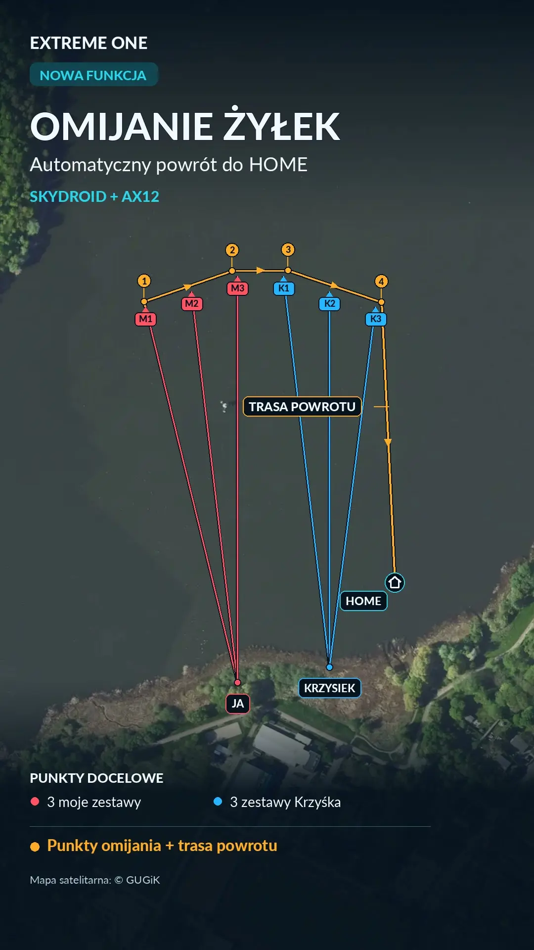
Avoiding virtual lines when returning HOME
Avoiding virtual lines in Extreme One helps you plan the boat’s return after dropping a rig. The system uses the markers saved in the app and shows waypoints leading back to HOME. The feature is available on Skydroid and AX12.
What the avoidance route looks like
In the example in the video, the boat first moves 5 metres further out, in line with the virtual line. At the outermost rigs there is also a sideways offset. The orange dots on the map show the return plan along the outside of the saved rigs.
Profiles for several anglers in one app
You can save separate angler profiles with their swims and virtual lines. The presentation shows three rigs belonging to one angler and three belonging to a friend, marked in different colours. The return plan takes into account the saved markers of both profiles.
Turning on avoidance before a bait run
- Select a rig on the map and the Go to target function.
- Turn on auto return and line avoidance.
- Check the waypoint preview and confirm the route.
Avoidance applies to the return after the drop. It is independent of the Fishing Zone. The video shows the app being operated and a simulation of the run along the planned route. The feature is based on the virtual lines saved by users.
Avoiding virtual lines: how the system knows where they are
The starting point is the swims and rigs saved in the app. A virtual line represents the link between a swim and the rig’s position on the map. That is why, before planning the return, it is worth checking that the markers match what you have actually set out on the water. If you have moved a rig, its previous entry does not automatically describe the new position.
Avoiding virtual lines uses this saved information to prepare waypoints. It does not require setting up a shared Fishing Zone or sending a friend’s code to a second app. In the use case shown, the angler profiles are on one device. This lets the system take their markers into account when planning a single return route for the boat.
Why the return goes further than the rig point itself
When the boat has dropped the rig, the shortest line to the bank is not always a suitable return path relative to the lines that are out. That is why the video shows the boat moving further out along the extension of the marked line. At the outermost rig, an additional point to the side helps lead the route around the outer part of the marked layout.
The distance of 5 metres is the value used in the example shown. The shape of the whole route and the position of HOME relative to the swim are also important. Check how the successive points connect with each other rather than only judging the first section after the drop. The orange markers let you look at the plan before confirming it and understand which way the boat will return.
Avoiding virtual lines and your friends’ profiles
Separate profiles help keep things organised when several people use one set of electronics. Each angler can have their own markers, and the colours make them easy to recognise on the shared map. Before a bait run it is worth going over the saved positions, especially if someone has just moved a rig or changed swim. The plan should be based on up-to-date markers.
Avoiding virtual lines as shown in the presentation takes into account three rigs of one angler and three of another. This layout explains how the feature works without having to create additional fishery boundaries. When watching the video, pay attention to the waypoints placed beyond the ends of the lines and the order in which they are passed on the way back to the saved HOME.
What to check in the preview before starting
First make sure you have selected the right target and that auto return is turned on. Then look at the route after the drop: the first section, the passage alongside the outermost rigs and the final approach to HOME. This is a clear moment to assess the plan before the boat starts the mission. Simply turning on the option should not replace looking at the map and the current layout of the swims.
In the video you see the app being operated and a simulation of the run. Avoiding virtual lines concerns the planned return after dropping a rig. It does not turn this presentation into a demonstration of the sonar detecting physical lines on its own. The feature is based on the markers users have entered into the system and the waypoints prepared from them.
After the bait run you can go back to the map and check the saved layout. If you are planning to move a rig again, update its marker first. This approach helps keep the map and the swim consistent and makes it easier for several anglers to share one app throughout the whole session.


 Karpik Kroczek, asystent Extreme One